‘Numerous flash floods’ are about to unfold in the Southwest from a double dose of tropically-fueled rain
By CNN Meteorologist Chris Dolce
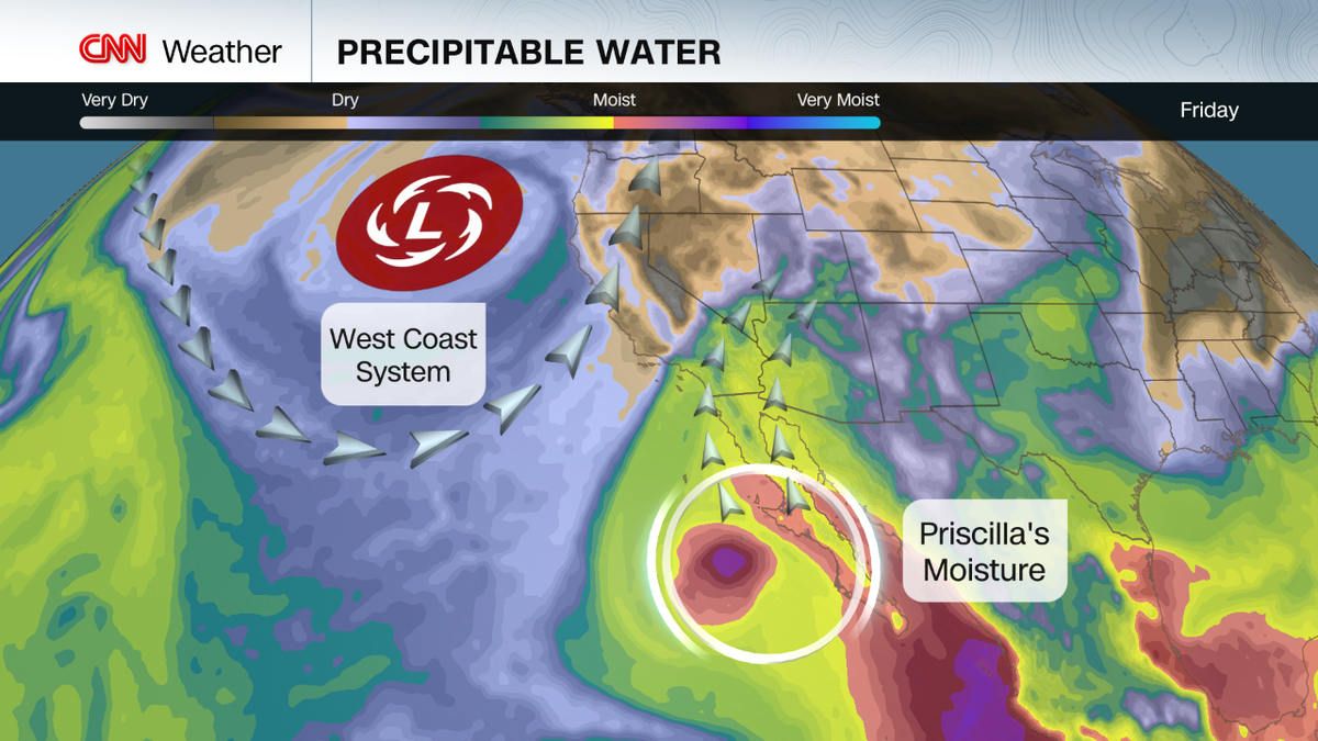
(CNN) — A serious multi-day flood threat is underway in the Southwest as two former tropical systems turn the typically dry desert into a breeding ground for heavy rain.
Soaking rainfall began over the region Thursday night as increasingly humid air arrived. Parts of the Phoenix metro had picked up a half-inch or more of rain by early Friday afternoon, with higher totals of 1 to 3 inches in the mountains north of there.
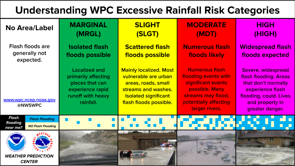
Flood watches cover parts of six states, with the bull’s-eye of the most serious flood concern in central and northeastern Arizona and southwest Utah now into Saturday morning. That’s where a Level 3 of 4 risk of flooding rainfall has been issued, according to the Weather Prediction Center. This means “numerous flash flooding events” are possible, some of which could be “significant,” the WPC said.
Former Hurricane Priscilla is helping to vault a record level of moisture for this time of year over the region, priming the atmosphere to produce rainfall totals from 1 to 4 inches. Combine that with the region’s mix of dry desert ground and mountainous terrain, and it’s a perfect recipe for rainfall to runoff quickly and trigger flooding.
Rainfall totals in a day or two could be nearly double the entire October average in Phoenix and Flagstaff. Phoenix typically sees about a half-inch in the month, while Flagstaff averages an inch and a half.
Washes, small streams and creeks and slot canyons could fill with rushing water and some could flood outside their banks during this event, so it’s best to avoid these areas. Recent wildfire burn scars could also see flooding and debris flows.
Most flood deaths occur on flooded roadways, since just 12 inches of water can float a car away.
Serious flooding like what happened in 2018 because of a similar forecast instigated by remnants of Hurricane Rosa could happen in the region, the WPC said. Numerous water rescues unfolded in Phoenix then after 2.36 inches of rain fell during a single day, the city’s wettest October day on record.
The threat stretches beyond Arizona. Areas from southeast California to southern Utah, southwest Colorado and western New Mexico also have an elevated risk of flooding into Saturday.
The flood threat will carry on into Sunday and Monday from a new tropical player arriving on the region’s doorstep.
Tropical Storm Raymond will fall apart by Sunday near northwest Mexico, but much like with Priscilla, its moisture will keep trucking north toward Arizona, New Mexico and southwest Texas.
The heaviest rain from this second round is expected to fall a bit farther east than what’s to come Friday into Saturday morning. Southeast Arizona, southern New Mexico and southwest Texas have the greatest risk of flash flooding from Saturday night through Sunday and Monday, including Tucson, Arizona, and El Paso, Texas.
What’s behind unusual amount of rain
It’s all happening in part because the remnants of former Hurricane Priscilla and Tropical Storm Raymond are juicing up the typically dry desert air over the Southwest US.
Think of the amount of moisture in the atmosphere like the amount of water in a sponge. The more there is, the more that can be wrung out by storms.
Priscilla dissipated Friday to the west of Mexico’s Baja California Peninsula. However, its moisture-rich air has been scooped up by a weather system riding through a dip in the jet stream along the West Coast.
Moisture and energy from Tropical Storm Raymond will play copycat and get steered by the same weather system into Mexico and the Southwest, although a bit farther east than Priscilla.
This is a classic weather pattern that has historically been responsible for slingshotting Eastern Pacific hurricane remnants into the Southwest US where they can trigger flooding rain. But seeing it happen in back-to-back fashion like this is a bit more unusual.
The-CNN-Wire
™ & © 2025 Cable News Network, Inc., a Warner Bros. Discovery Company. All rights reserved.
