Marine heat wave impacting California coastal water temperatures


By CBS Bay Area
Many people know El Niño is currently bringing warmer-than-normal sea surface temperatures to the equatorial Pacific, but there is also a completely different marine heat wave that’s been impacting California for well over a year.
There’s been a blob of warmer-than-normal water sitting off the Central and Southern California coast since May 2025, along with a new marine heat wave that developed far offshore in May of this year, but it’s not directly impacting the coast yet. Water temperatures in Southern California, from San Diego to Santa Barbara, have been in the mid-70s, which is anywhere from 5-10° above normal.
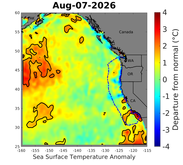
Central California’s marine heat wave is a little less noticeable, but it is still there, with water temperatures a few degrees above average. Monterey has been in the low 60s compared to the upper 50s; San Francisco has been in the upper-50s vs. mid to upper 50s. As the heat wave spreads north up the West Coast, these water temperatures will remain 5-10° above average.
This has kept Southern and Central California way more humid than normal, mainly because warmer water evaporates quicker, which directly adds more moisture to the air, making it feel more humid. Also, with El Niño, there are more hurricanes in the Pacific, and some of that tropical moisture is able to make its way to the West Coast.
Winds are a main reason why. They are a huge driver for keeping the California coast cool. Normally, they blow from north to south along the West Coast, which causes an “upwelling” of deeper, colder, nutrient-rich waters to rise to the surface, displacing warmer surface waters offshore. This is the typical California Current.
But when winds are weak, or blow from south to north, upwelling stops or even reverses, which allows surface waters to warm along the coast and can cause warmer offshore waters to move towards land.
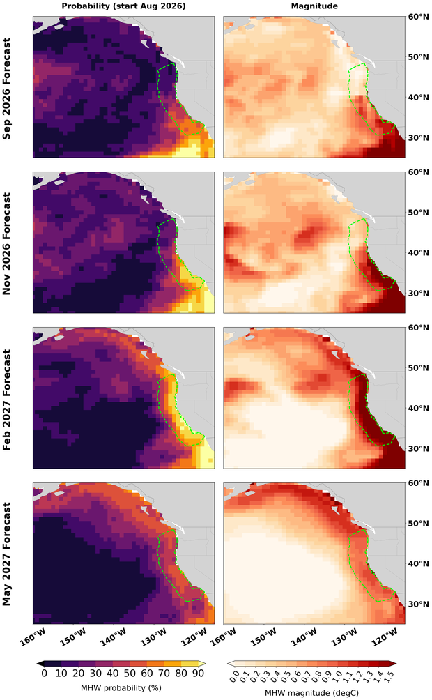
The National Oceanic and Atmospheric Administration released a marine heat wave forecast and says there’s an 80-100% chance that it will continue through the end of this year.
By February of next year, models have it extending all the way up to Canada. It’s not the intensity, but the prolonged nature of this marine heat wave that will cause widespread impacts across the West Coast.
These marine heat waves can trigger widespread ecological collapse and intensify extreme weather. Monterey Bay National Marine Sanctuary has been categorized as under a heat wave for 194 days so far this year; last year, it was 130 days total.
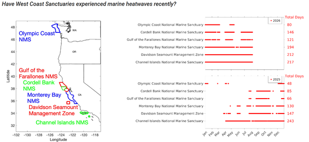
Almost all Marine Sanctuaries off the West Coast have already seen more days with hot sea surfaces so far this year compared to all of last year. It can also bring more intense atmospheric rivers, especially to Southern California, this winter, which is what most long-range weather models are beginning to point toward.